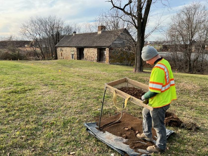
The Threatened Sites Grant Program: Fiscal Year 2026
Each year, DHR provides grant funding for archaeological sites endangered by erosion, impending developments, or vandalism. These sites range in age from thousands of years old to the early 20th century. For fiscal year 2026, the Threatened Sites program is funding five projects from across the state.
Submitted by Elizabeth Moore | DHR Director of State Archaeology
Mount Hermon Pottery, Rockingham County
The site identified as the Mount Hermon pottery was discovered by three avocational historians/archaeologists in 2019. The site includes the remnant of a pottery kiln, a possible shop building with a stone-lined cellar for storing clay, clay extraction pits, the limestone quarry source for the kiln base and chimney walls, and at least two waster dump deposits. Very few archaeological examples of pottery kilns are known from the Shenandoah Valley, despite the former presence of many potteries. The Morris Kiln (Rockingham County) received early archaeological investigations and preliminary mapping of kiln features (Espenshade 2022), and the Fincastle kiln was excavated in 1990 in Botetourt County (Russ 1990). The site is threatened by several vectors of disturbance: 1) cattle crushing and displacement of artifacts; 2) ongoing erosion of deposits on Quail Run; 3) wind and rain erosion of site features exposed by avocational investigations; 4) future avocational collection of artifacts; and 5) annexation and residential development. This project will include drone-based LiDAR to centimeter resolution that will produce a bare-earth topographic map of the project area and a report of the examination and interpretation of the material culture excavated and the survey results. Faculty in the Environmental, Geographical and Geological Sciences (EGGS) program at Commonwealth-Mansfield will lead this project. Expertise in the archaeology of pottery production sites will be provided by Chris Espenshade, an independent researcher with expertise in the potters of Virginia.
Archaeological Investigation and Excavation at Site 44KW0017, Pamunkey Indian Reservation
The site of a proposed new home for a family of Pamunkey Tribal Citizens is located within the bounds of Site 44KW0017. 44KW0017 is a site of high significance, recognized by Tribal cultural knowledge, included in the Reservation’s 1982 National Register of Historic Places nomination, discussed in ethnographies of the early 20th century, and further confirmed by Phase I and II archeological studies. Recent Phase I and II investigations have identified intact stratified cultural deposits, and chances of identifying further features and dense artifact concentrations within this yard are high. Phase II test unit excavation in 2025 resulted in a large assemblage of artifacts consisting primarily of flakes, pre-contact ceramic, and post-contact domestic material, along with eight features, five of which are likely associated with a yehakin, or longhouse, structure. With these features, Site 44KW0017 illustrates a level of integrity not seen elsewhere on the Reservation to this point, mostly due to lack of testing. This project will include GPR survey, targeted excavation and construction siting recommendation, excavation of impacted features, laboratory analysis, oral history collection, documentation, and reporting.
Maritime survey of the Pamunkey River in the area around Bassetts Landing
Located in Hanover County, about 20 miles upriver from White House Landing, Bassetts Landing served as both a ferry crossing to the King William side of the Pamunkey River and the river landing for George Washington Bassett’s plantation at Clover Lea, which was completed by 1844 (Virginia Landmarks Register 2024). When Confederate forces abandoned Yorktown in early May 1862, the supply boats serving them were left stranded upriver. To prevent the Union from seizing the cargo, the crews destroyed all the vessels on 17 May 1862 (Navy Department 1963:588 9). Among them was the Logan, the largest vessel—a 160-foot iron-hulled sidewheel steamer (Navy Department 1963:544). This project will conduct a remote-sensing survey of the Pamunkey River in the vicinity of Bassett’s Landing. The data will be analyzed and interpreted to identify potentially significant cultural resources within the survey area that are currently threatened by artifact collectors.
Patawomeke Chronology Project
This project will generate new Accelerator Mass Spectrometry (AMS) radiocarbon dates for the Potomac Creek site (44ST2). The site 44ST2 is continually threatened by shoreline erosion, residential development, and sea-level rise. The historical successor to this village, 44ST1, is already almost entirely eroded into the Potomac River. Both sites are the ancestral homes of the Patawomeck Indian Tribe of Virginia and were significant in the historical developments of the Potomac River drainage. The current project was initiated at the behest of the Patawomeck Tribe and aims to provide important information regarding the cultural history of the Tidewater Potomac and the development of their ancient village. The model resulting from this analysis will not only clarify the temporal boundaries for when occupation begins and ends, but it may also provide valuable insight into the history of the precolonial deerskin trade within the Potomac drainage and identify this community's role within that trade. This research will serve to inform and guide future investigations of the site, Indian Point, and the broader Potomac Creek landscape before additional significant erosional loss occurs.
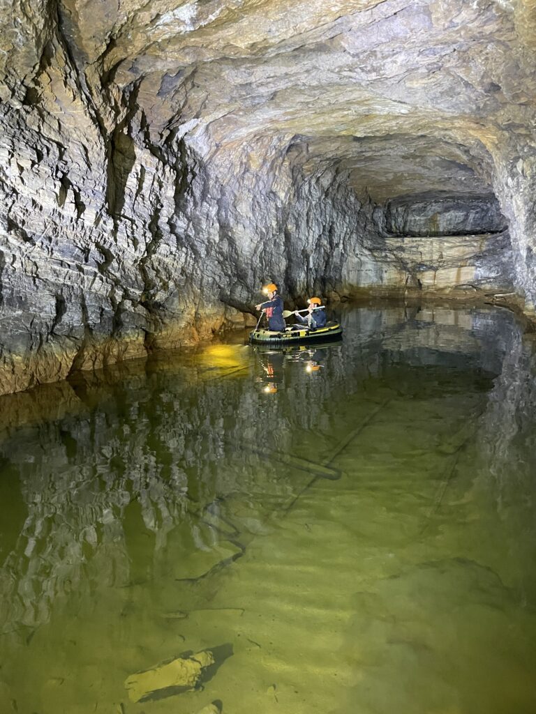
Digital Preservation of Above-Ground Resources of the Marshall Tunnel Canal District
This grant will fund the completion of the digital documentation of the Marshall Tunnel Canal District in Botetourt County, Virginia. Previous fieldwork focused on the subterranean cultural features. This phase will document a series of canal locks and industrial features. The Marshall Tunnel Canal District contains 13 features associated with an attempt to create a 1,900-foot tunnel through a mountain spur known as Timber Ridge. Funding for construction ran out in 1856 and left the site in its present unfinished state. Features within the district include an aqueduct, canal locks, retaining walls, spoil piles, construction roadways, a horse gin, and an unlocated labor camp occupied by more than 90 individuals for three years. The site is exemplary of 19th-century canal technology and is singular in nature due to the unfinished state of the works. As part of the project, small trees and brush will be cleared from the features with the assistance of volunteers from the Virginia Canal and Navigational Society. The documentation will include a combination of terrestrial laser scanning and photogrammetry, producing 3D models of the features that can be shared with the public as well as used to create other deliverables including orthomoasic images and fly-through videos.