How do we know about the Native Americans who were here when the first Europeans arrived?
Archaeology supplies us with some evidence, along with the writings of the first visitors and the stories of the Native Americans themselves.
The artwork of John White is another source of evidence. Long before the invention of photography, he painted scenes of what he saw of Native American life from a visit in 1585.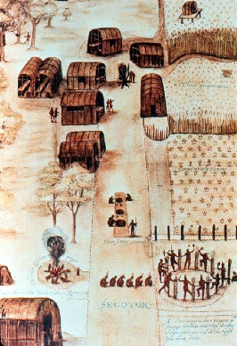
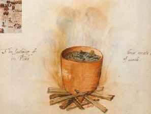
John White painted a clay pot on a wooden fire. It’s hard to see the contents but there may be corn, fish, meat and other grains or vegetables. The label say: “The seething of their meate – in Potts of earth.” What do you think archaeologists might find of this meal 400 years later?
Eight organized Indian groups together make up on the largest populations of Native Americans on the East Coast. These include the Pamunkey and the Mattaponi, two tribes in King William County. Their state reservations date from the 1600s. Six other incorporated groups are officially recognized as Indian tribes by the State of Virginia. They are all from the Algonquian language group except for the Monacan.
The Chickahominy Indian Tribe was among those which witnessed the coming of the colonists in 1607. The tribe’s territory ranged from Jamestown to the “fall line,” near present-day Richmond. The tribe, ruled by a council of elders, was considered an ally of the Powhatan and his chiefdom. The Treaty of 1614 between the Chickahominy and the colonists provided that the Chickahominy would supply 300-400 bowman to fight the Spanish if necessary. It appears that the colonists were more afraid of the Spanish than they were of the Indians. When the Indians were sent to “Pamunkey Neck” in what is now King William County, the Chickahominy joined the other tribes. After 1718, the Indians were forced off that reservation. The Chickahominy Tribe moved back to the homeland in present-day Charles City and New Kent counties. The tribe reorganized in 1900, led by a chief, assistant chief, and a tribal council. The tribe is Virginia’s largest with approximately 1,000 members.
Eastern Chickahominy
Located in New Kent County 25 miles east of Richmond, the eastern division of the tribe has 150 members. It was formed in 1925 after a split with the Chickahominy Indian Tribe. Now it is incorporated as a tax-exempt organization to serve the educational, religious, and other needs of its members.
Mattaponi
This King William County tribe of some 100 members lives on a reservation along the Mattaponi River near West Point, Virginia. The tribe traces its history back to the Powhatan chiefdom that greeted the settlers in 1607. At this time, the Mattaponi, along with other original Powhatan tribes, were visited by Captain John Smith. The reservation dates back to 1658 and is one of the oldest in the United States. While many other tribes have been displaced, the Mattaponi have persisted as a result of their strong traditions, ceremonies, and leadership qualities which have held the tribe together. Today, the Mattaponi’s pride in their cultural heritage is greater than ever. Shad have always been a staple in the Mattaponi diet and at the center of their culture. These traditions continue as the Mattaponi people work in harmony with the land and the river at the tribal Fish Hatchery and Marine Resource Center.
Monacan
The Monacan live in the Piedmont region, west of the other state-recognized tribes. Along with other Siouan-speaking tribes such as the Saponi, Tutelo, and Mannahoac, they once occupied most of the western half of what is now Virginia. Early settlers wrote little about them, both because they were enemies of the Powhatan, and because they chose not to interact with the English. The Monacan are self-governed by a chief, assistant chief, and Tribal Council elected by tribal members. The population today is more than 1,400 people. The tribe is focused on revitalizing its cultural traditions and language. To preserve its heritage, the tribe developed its own museum, which displays both artifacts and modern exhibits. It is located at the site of Bear Mountain, the spiritual center of the Monacan people and the location of an Episcopal mission church established in 1908. Today the old log cabin schoolhouse is a restored national historic landmark, and the tribe operates a food bank, elder program, youth cultural program, and many other projects that benefit tribal members.
Nansemond
At the time of the Jamestown Settlement in 1607, the Nansemond tribe was located in the general area of Reeds Ferry near Chuckatuck, in the current City of Suffolk. The chief lived near Dumpling Island where he kept his religions houses. The tribe had a population of approximately 850 with 200 bow-men. In 1608, Jamestown was suffering from a severe food shortage. John Smith attempted to bargain with the Nansemond Indians with varying degrees of success. The endeavor ended in open hostilities. It has been said that the Nansemond became the granary of the early colonists. As increasing numbers of settlers moved up the Nansemond River, the Nansemond Indians relocated their reservation and tribal land several times. They sold their last 300 acres, located on the Nottoway River in Southhampton County, in 1792. One group of Christianized Nansemond moved and settled in the Bowers Hill, Deep Creek area on the fringe of the Great Dismal Swamp in the late 1600s. Their descendants still live in that location and surrounding areas. Pamunkey One hundred members of this tribe live on a reservation in King William County on the Pamunkey River. The Pamunkey Indians were one of the most powerful of the tribes in the Powhatan chiefdom. The chiefdom consisted of approximately 32 districts and over 10,000 people under the leadership of the ruling Powhatan. The Powhatan territory encompassed most of the Coastal Plain of Virginia from the North Carolina border to Washington, D.C. Chief Powhatan and his famous daughter Pocahontas lived among the Pamunkey. The Pamunkey enjoy the distinction of being one of the tribes east of the Mississippi who have practiced the art of pottery making continuously since aboriginal times. Through the school year, school children who are studying Indian life visit the reservation, purchase souvenirs, and join the Indians in traditional native dances.
Rappahannock
In 1607, the Rappahannock were the dominant tribe of the Rappahannock River Valley, maintaining 13 villages along the north and south banks of the river that bears their name. The Rappahannock territory encompassed lands in the modern counties of Richmond, Northumberland, Lancaster, Essex, and Caroline. The king’s town was located at “Cat Point Creek” or “Dancing Point” as known to the tribe, near present-day Warsaw, Virginia. It was here, in December 1607, that the Rappahannock first met Captain John Smith. He was brought to see the king at “Toppahanoke” while Opechancanough held him captive. Over the next 40 years, English settlement expanded up the Rappahannock River, and after 1649 the Rappahannock were gradually forced inland. The Rappahannock formally organized in 1921, when they incorporated with the state. Members of the tribe established the Rappahannock Indian Baptist Church for their community in 1964. In 1983, the Rappahannock gained official recognition from the Commonwealth as one of Virginia’s historic tribes. In 1998, they elected the first woman chief to lead in Virginia since the 1700s, Chief G. Anne Richardson. Their mission is to preserve Rappahannock culture and social/political structures, establish a tribal land/trust, and implement housing and economic development projects while educating the public on the rich contributions they have made and continue to make to Virginia and the nation.
The Upper Mattaponi
The Upper Mattaponi Indian Tribe resides close to the upper reaches of the Mattaponi River near Aylett in present-day King William County, Virginia. Archaeological evidence provides information about extensive Indian culture in this region for thousands of years. In 1608, Captain John Smith identified the village of Passaunkack at the location of the present-day Upper Mattaponi. In 1676, the August Hermann Map shows several Indian houses along the Upper Mattaponi River directly at the location of the Upper Mattaponi people, identifying that region as Indian land. From 1702 to 1727, an official interpreter of the Indians to the British named James Adams lived near this area, and an 1863 Civil War map also identifies the area as Indian land. During that era the local Indians were known as the Adamstown band, because so many of them had the last name Adams. In 1921 the Adamstown Indians officially became the Upper Mattaponi Indian Tribe. In the late 1800s, the Upper Mattaponi had a school that existed for a short time, and, in 1919, a one-room structure was built. This school served the Upper Mattaponi until 1952, when a modern brick structure replaced it. This structure stands today as the only public Indian school building in the state of Virginia and it has been officially recognized for its historic significance. Today, the building also serves as the tribal center. Next door to the school is the Indian View Baptist Church, which was built in 1942 and still serves as the home church for many of the Upper Mattaponi people. Today the Upper Mattaponi also own 32 acres of land and have been working diligently towards federal acknowledgement. They are a proud, humble people with strong character and values, with much optimism and hope for the future.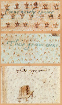 Parts of the village painting seem to be put together from different drawings. For the corn, however, White was showing the Native Americans managing multiple plantings. This meant that the corn would be available throughout more of the year.
What do you think the hut in the field of ripe corn was for?
– The hut was a shelter for a person to scare away the birds.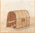
What do you think would be left of this building 400 years later?
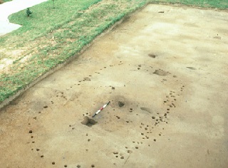
Archaeologists found color discoloration showing where the posts were in the ground.
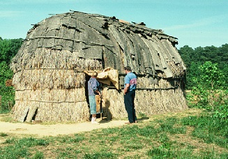
Did you notice that the color discoloration in the ground from the posts formed a round end, instead of a flat end in the pictures. When archaeologists at St. Mary’s City reconstructed one of the houses they found the rounded end made the building much more sturdy. John Smith was one of the first Europeans to explore the Indian settlements. His description of the Native American houses is below: “The houses are built like our Arbors of small young springs [saplings] bowed and tyed, and so close covered with mats, or the barkes of trees … that notwithstanding either winde, raine or weather, they are as warme as stoves, but very smoaky. ” John Smith, 1612
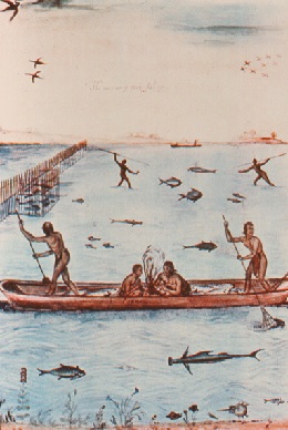
This drawing is made up from many different parts. While each part might be accurate they could not have all happened together.
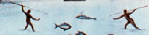
How deep is the water? During the day the Native Americans were fishing with spears.
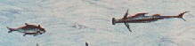
Is that a shark? The other fish shown may be a burrfush and neither would probably have been seen in shallow waters.
There seems to be a fire in the canoe! Perhaps the men were fishing at night.

The Indians used fish-weirs to trap fish. There were likely put in shallower water.

How deep is the water? The fish shown, burrfish, skate or ray, hammerhead sharks, are more likely to be out to sea.
Archaeology supplies us with some evidence, along with the writings of the first visitors and the stories of the Native Americans themselves.
The artwork of John White is another source of evidence. Long before the invention of photography, he painted scenes of what he saw of Native American life from a visit in 1585.
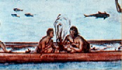
Can you find all activities that are going on in this painting?
Cooking
John White painted a clay pot on a wooden fire. It’s hard to see the contents but there may be corn, fish, meat and other grains or vegetables. The label say: “The seething of their meate – in Potts of earth.” What do you think archaeologists might find of this meal 400 years later?
Dancing
The painting shows people dancing and praying. The posts appear to have human faces carved into them. The dance might be a green corn, or harvest ritual dance, based upon the time of the year that the painting was completed. The painting shows a lot of animation and possibly noise from the instruments and stamping and clapping, but it’s hard for a painting, or archaeology, to tell us much about the people’s spiritual beliefs and practices. In Virginia we can learn more about Native Americans from existing tribes.Native American Tribes in Virginia.
Today, about 3,500 people of Indian ancestry live in Virginia as members of state recognized tribes. Their names are entered in the tribal register, with their solemn pledge to uphold the traditions of the tribe. Census figures hold that 25,120 more people of American Indian, Alaskan and Hawaiian ancestry live in urban areas, such as Tidewater, Northern Virginia, Roanoke, and Richmond.Eight organized Indian groups together make up on the largest populations of Native Americans on the East Coast. These include the Pamunkey and the Mattaponi, two tribes in King William County. Their state reservations date from the 1600s. Six other incorporated groups are officially recognized as Indian tribes by the State of Virginia. They are all from the Algonquian language group except for the Monacan.
Virginia Tribes.
ChickahominyThe Chickahominy Indian Tribe was among those which witnessed the coming of the colonists in 1607. The tribe’s territory ranged from Jamestown to the “fall line,” near present-day Richmond. The tribe, ruled by a council of elders, was considered an ally of the Powhatan and his chiefdom. The Treaty of 1614 between the Chickahominy and the colonists provided that the Chickahominy would supply 300-400 bowman to fight the Spanish if necessary. It appears that the colonists were more afraid of the Spanish than they were of the Indians. When the Indians were sent to “Pamunkey Neck” in what is now King William County, the Chickahominy joined the other tribes. After 1718, the Indians were forced off that reservation. The Chickahominy Tribe moved back to the homeland in present-day Charles City and New Kent counties. The tribe reorganized in 1900, led by a chief, assistant chief, and a tribal council. The tribe is Virginia’s largest with approximately 1,000 members.
Eastern Chickahominy
Located in New Kent County 25 miles east of Richmond, the eastern division of the tribe has 150 members. It was formed in 1925 after a split with the Chickahominy Indian Tribe. Now it is incorporated as a tax-exempt organization to serve the educational, religious, and other needs of its members.
Mattaponi
This King William County tribe of some 100 members lives on a reservation along the Mattaponi River near West Point, Virginia. The tribe traces its history back to the Powhatan chiefdom that greeted the settlers in 1607. At this time, the Mattaponi, along with other original Powhatan tribes, were visited by Captain John Smith. The reservation dates back to 1658 and is one of the oldest in the United States. While many other tribes have been displaced, the Mattaponi have persisted as a result of their strong traditions, ceremonies, and leadership qualities which have held the tribe together. Today, the Mattaponi’s pride in their cultural heritage is greater than ever. Shad have always been a staple in the Mattaponi diet and at the center of their culture. These traditions continue as the Mattaponi people work in harmony with the land and the river at the tribal Fish Hatchery and Marine Resource Center.
Monacan
The Monacan live in the Piedmont region, west of the other state-recognized tribes. Along with other Siouan-speaking tribes such as the Saponi, Tutelo, and Mannahoac, they once occupied most of the western half of what is now Virginia. Early settlers wrote little about them, both because they were enemies of the Powhatan, and because they chose not to interact with the English. The Monacan are self-governed by a chief, assistant chief, and Tribal Council elected by tribal members. The population today is more than 1,400 people. The tribe is focused on revitalizing its cultural traditions and language. To preserve its heritage, the tribe developed its own museum, which displays both artifacts and modern exhibits. It is located at the site of Bear Mountain, the spiritual center of the Monacan people and the location of an Episcopal mission church established in 1908. Today the old log cabin schoolhouse is a restored national historic landmark, and the tribe operates a food bank, elder program, youth cultural program, and many other projects that benefit tribal members.
Nansemond
At the time of the Jamestown Settlement in 1607, the Nansemond tribe was located in the general area of Reeds Ferry near Chuckatuck, in the current City of Suffolk. The chief lived near Dumpling Island where he kept his religions houses. The tribe had a population of approximately 850 with 200 bow-men. In 1608, Jamestown was suffering from a severe food shortage. John Smith attempted to bargain with the Nansemond Indians with varying degrees of success. The endeavor ended in open hostilities. It has been said that the Nansemond became the granary of the early colonists. As increasing numbers of settlers moved up the Nansemond River, the Nansemond Indians relocated their reservation and tribal land several times. They sold their last 300 acres, located on the Nottoway River in Southhampton County, in 1792. One group of Christianized Nansemond moved and settled in the Bowers Hill, Deep Creek area on the fringe of the Great Dismal Swamp in the late 1600s. Their descendants still live in that location and surrounding areas. Pamunkey One hundred members of this tribe live on a reservation in King William County on the Pamunkey River. The Pamunkey Indians were one of the most powerful of the tribes in the Powhatan chiefdom. The chiefdom consisted of approximately 32 districts and over 10,000 people under the leadership of the ruling Powhatan. The Powhatan territory encompassed most of the Coastal Plain of Virginia from the North Carolina border to Washington, D.C. Chief Powhatan and his famous daughter Pocahontas lived among the Pamunkey. The Pamunkey enjoy the distinction of being one of the tribes east of the Mississippi who have practiced the art of pottery making continuously since aboriginal times. Through the school year, school children who are studying Indian life visit the reservation, purchase souvenirs, and join the Indians in traditional native dances.
Rappahannock
In 1607, the Rappahannock were the dominant tribe of the Rappahannock River Valley, maintaining 13 villages along the north and south banks of the river that bears their name. The Rappahannock territory encompassed lands in the modern counties of Richmond, Northumberland, Lancaster, Essex, and Caroline. The king’s town was located at “Cat Point Creek” or “Dancing Point” as known to the tribe, near present-day Warsaw, Virginia. It was here, in December 1607, that the Rappahannock first met Captain John Smith. He was brought to see the king at “Toppahanoke” while Opechancanough held him captive. Over the next 40 years, English settlement expanded up the Rappahannock River, and after 1649 the Rappahannock were gradually forced inland. The Rappahannock formally organized in 1921, when they incorporated with the state. Members of the tribe established the Rappahannock Indian Baptist Church for their community in 1964. In 1983, the Rappahannock gained official recognition from the Commonwealth as one of Virginia’s historic tribes. In 1998, they elected the first woman chief to lead in Virginia since the 1700s, Chief G. Anne Richardson. Their mission is to preserve Rappahannock culture and social/political structures, establish a tribal land/trust, and implement housing and economic development projects while educating the public on the rich contributions they have made and continue to make to Virginia and the nation.
The Upper Mattaponi
The Upper Mattaponi Indian Tribe resides close to the upper reaches of the Mattaponi River near Aylett in present-day King William County, Virginia. Archaeological evidence provides information about extensive Indian culture in this region for thousands of years. In 1608, Captain John Smith identified the village of Passaunkack at the location of the present-day Upper Mattaponi. In 1676, the August Hermann Map shows several Indian houses along the Upper Mattaponi River directly at the location of the Upper Mattaponi people, identifying that region as Indian land. From 1702 to 1727, an official interpreter of the Indians to the British named James Adams lived near this area, and an 1863 Civil War map also identifies the area as Indian land. During that era the local Indians were known as the Adamstown band, because so many of them had the last name Adams. In 1921 the Adamstown Indians officially became the Upper Mattaponi Indian Tribe. In the late 1800s, the Upper Mattaponi had a school that existed for a short time, and, in 1919, a one-room structure was built. This school served the Upper Mattaponi until 1952, when a modern brick structure replaced it. This structure stands today as the only public Indian school building in the state of Virginia and it has been officially recognized for its historic significance. Today, the building also serves as the tribal center. Next door to the school is the Indian View Baptist Church, which was built in 1942 and still serves as the home church for many of the Upper Mattaponi people. Today the Upper Mattaponi also own 32 acres of land and have been working diligently towards federal acknowledgement. They are a proud, humble people with strong character and values, with much optimism and hope for the future.
Farming
In the painting John White shows corn growing in three stages:- Corne newly spryng
- Their greene corne
- Their rype corne
Parts of the village painting seem to be put together from different drawings. For the corn, however, White was showing the Native Americans managing multiple plantings. This meant that the corn would be available throughout more of the year.
What do you think the hut in the field of ripe corn was for?
– The hut was a shelter for a person to scare away the birds.
Building
What do you think would be left of this building 400 years later?
Archaeologists found color discoloration showing where the posts were in the ground.
Did you notice that the color discoloration in the ground from the posts formed a round end, instead of a flat end in the pictures. When archaeologists at St. Mary’s City reconstructed one of the houses they found the rounded end made the building much more sturdy. John Smith was one of the first Europeans to explore the Indian settlements. His description of the Native American houses is below: “The houses are built like our Arbors of small young springs [saplings] bowed and tyed, and so close covered with mats, or the barkes of trees … that notwithstanding either winde, raine or weather, they are as warme as stoves, but very smoaky. ” John Smith, 1612
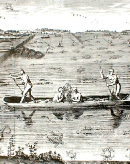
Did John White paint things exactly as they happened?
After the original painting was made another man called Thomas de Bry made copies of the paiting. Campare this ‘copy’ with the original. Is it an exact copy? What differences do you see? Is this an accurate copy?
This drawing is made up from many different parts. While each part might be accurate they could not have all happened together.
How deep is the water? During the day the Native Americans were fishing with spears.
Is that a shark? The other fish shown may be a burrfush and neither would probably have been seen in shallow waters.
There seems to be a fire in the canoe! Perhaps the men were fishing at night.
The Indians used fish-weirs to trap fish. There were likely put in shallower water.
How deep is the water? The fish shown, burrfish, skate or ray, hammerhead sharks, are more likely to be out to sea.
Updated March 1, 2021